Jump to content

Search the Community

Showing results for tags 'map'.

  • Search By Tags

    Type tags separated by commas.
  • Search By Author

Content Type


Forums

  • Fishing Forums
    • General Bass Fishing Forum
    • Introductions
    • Smallmouth Bass Fishing
    • Fishing Reports
    • Bass Clubs
  • Bass Boats & Fishing Equipment
    • Fishing Tackle
    • Bass Boats, Canoes, Kayaks and more
    • Tacklemaking
    • Fishing Rods, Reels, Line, and Knots
    • Rod Building and Custom Rods
    • Marine Electronics
  • Bass Fishing Tournaments
    • Tournament Talk
    • Fishing Résumés
  • Fishing Locations
    • Southeast Bass Fishing
    • Northeast Bass Fishing
    • Central Bass Fishing
    • Western Bass Fishing
    • International Bass Fishing
  • More Topics
    • Other Fish Species
    • Fishing Flea Market
    • Everything Else
  • Hunting
    • Hunting Forum
    • Gun Forum

Find results in...

Find results that contain...


Date Created

  • Start

    End


Last Updated

  • Start

    End


Filter by number of...

Joined

  • Start

    End


Group


Location


My PB


Favorite Lake or River


Other Interests

Found 9 results

  1. when you are breaking down a map how msny spots will you mark? is it dependant on lake size or what you think will hold fish? i typically dont use topo maps as there is only a few spots to fish deep (15+) on the 2 lakes close to me and ive fished the lakes numerous times... but the lake im looking at is a powerplant lake ive never fished of about 2500 acres with an average depth of 18 and max depth around 45... ive started breaking the map down by main lake, and each arm and coves. i have about 30 spots marked that i would like to check out over time as i fish it... also ive searched and read multiple forums and watched videos about breaking them down. any good videos youd recommend?? thanks
  2. I'm not sure if this is the right area of the forum to post this, but i've been looking for a map of Kentucky Lake from Paris to New Johnsonville for an upcoming tournament in September. I've been able to find a map for pretty much anywhere else on Kentucky Lake but not for the particular side i'll be fishing. If anyone can point me in the right direction it would be greatly appreciated.
  3. Hey Gang!, I'm working on a small project over the winter where I take lake information found on various state websites and plug it into a map. This includes average water clarity, vegetation type, bottom material, etc, etc. I really want to add primary forage fish and maybe even primary crawfish type to the map to get a better sense of how everything relates. This doesn't have to be precise like the other information I'm gathering, but I'd like it to be exact as possible. Distribution and region maps aren't as detailed as they could be - unless I'm looking wrong. When distribution in mentioned, it's usually in general terms ("East Texas"). I could call parks and wildlife departments or fisheries managers and get the info, but that's a last resort action. Does anyone have really good resources for this stuff? Do you see an easier way of gathering the data? Thank you! Tom
  4. http://cteco.uconn.edu/map_catalog/maps/lake/bathymetry/Bathymetry_With_Aerial_Tyler_Lake.pdf Hi, I was wondering if anybody could give me some advice on fishing this lake (copy URL above into browser for lake map) in the summer? I've tried many tactics, but they all seem to fail miserably. I am Kayak fishing so any location is accessible. Help would be MUCH appreciated
  5. Hey guys, Just wanted to see how you would break down this last pond that my local club is fishing for the year. Most of the guys stop fishing in early August and start gearing up for the hunting season - I'm hoping to make a run at taking this last tournament. I've fished this pond for fun several times, but most of that time is spent helping other non-fisherman/women learn how to cast or fish a specific type of lure (I take a lot of people from work etc out on the boat because they wanted to try non-bobber fishing or whatever. I attached the DNREC PDF file that has the pond map on it, as well as our Dept of Natural Resources break down of their electrofishing studies on the pond. Would be very interested to see how you guys would break down this small pond, and where you would fish it during the tournament. Personally I think the spillway (near the boat ramp - 9 foot section) and the far bank paralleling Lake Drive all the way back to Lavinia Street (where a culvert pipe sticks into the water) is where I am going to focus. The long skinny branch of the pond is very shallow, and the entirety of the pond is choked with underwater vegetation (Hydrilla) and lily pads. Anyways - long winded post, any thoughts appreciated on how you would approach it Wagamons Pond.pdf
  6. i have a couple of local lakes in my area ive been fishing for a good while now and i just started hearing about topo maps i don't know why i just started hearing about them. I was wondering if anyone knows how i can get a hold of one for my local lakes because ive looked every were it seems as if it doesn't exist. Or is there a way i can get one made? They aren't big lakes but they are state parks. Thanks
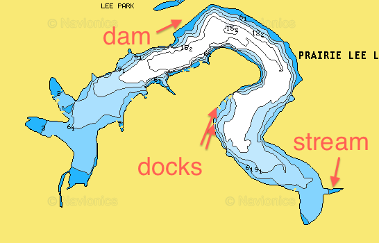
  7. Hello, so we have finally got a boat after all this time, fishing from shore on this lake. Since i'm new to this, it would be great help if someone could examine this map and by what the map says tell me what would be the best places in pre-spawn, spawn, post, summer, fall. Im not planing on fishing in winter. But by what you see on this, could you try to be detailed/specific on the best places for largemouth during those times of the season, etc. There is one part of the lake that is weedchoked, (you will see on map.) If it is possible with our boat to get back in thicker weeds, what should i fish with? If it would be easier to help through email, i will reply with my email username, and we can go from there. I would greatly appreciate the help, because i like to catch fish "haha!" Thanks, Zach I Had the pdf file attached but too many people downloaded it, with no help. So if you would truly want to help, just ask for the file. I will post briefly or find someway to do it
  8. Hey guys, I finally found a topo map for the lake that I fish. Where do you guys think would be good to fish on this map? Not really how to read one (watched videos on that) but spots where you think fish would be. There should be a picture of the map attached. Thanks in advance!
  9. I don't know if this is the right forum. A mod can move if its in wrong area. Sorry if it is. Your trip to Pickwick looks awesome but had my trip planned before. Taking my father to Lake Guntersville Alabama. I seen you guys went last year and had success. Taking my father as a father son trip. Any ideas where I can get a detailed map of the lake? Maybe from a website.. I want to know where structure is or drop offs. I know u can get that off a finder when fishing but want to study before I go like Mike Iacanelli does. Any idea on map and where to get one from? Ill pay for one if I have to. Thanks for your help.
×
×
  • Create New...

Important Information

We have placed cookies on your device to help make this website better. You can adjust your cookie settings, otherwise we'll assume you're okay to continue.