Hey guys I just figured something out and wanted to share it. This is for the guys that don't have a lot of money invested in their electronics yet. I will one day but i'm not to that point yet. I have figured out how to get waypoints on google earth on my phone. I didn't find any other topics on this exact subject so figured I'd start one.
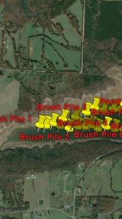
Basically what i did was use old imagry of a lake when it was drawn way down and marked brush piles, humps, old pond banks, foundations, and road beds. On a little 1200 acre lake i have over 60 places marked.
After I marked my spots on Google earth I right clicked on the folder I create for this set of waypoints, right clicked on the folder under my places and emailed it to myself. I opened the email on my phone then opened the file in google earth.
I was worried about the accuracy of the GPS on my phone, but after testing it in my back yard I believe i can well within 10ft of my waypoint.
It will be another week or two before i get to test it, but I can't see why it won't work.
Thanks!