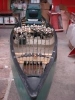
Super User Fishing Rhino Posted September 24, 2013 Super User Posted September 24, 2013 This is the route from the public access ramp to one of the ponds near my home. Photos taken on my return to the ramp, which can be seen in the last photo in the top left corner of the photo. You can also see the guard rail of the "highway" just above the ramp. Yes, those are rocks in the third photo. If I had a wide angle lens, you would have seen that it looked much the same on the opposite side of the "channel" A few years ago there were a couple of guys who took their Bass Trackers through this channel. And there was one hardy, though not too bright soul who traversed this route in a very nice Ranger. One on the trolling motor, the other on the stern with a push, or pull pole (boat hook) to keep the fiberglass hull off the rocks. The purple loosestrife vines had not intruded quite so much into the channel, and the water level was about a foot higher. For some reason, Fall River, which owns the water rights to the pond lowered the level to keep South Watuppa in balance, whatever that means. It's a five minute cruise, provided that you don't get hung up along the way. 1 Quote
Brian6428 Posted September 24, 2013 Posted September 24, 2013 Thats crazy! Looks like an area i would go just for fun in my bass raider, though lol. Does the lake get much pressure? Quote
Super User Fishing Rhino Posted September 24, 2013 Author Super User Posted September 24, 2013 Thats crazy! Looks like an area i would go just for fun in my bass raider, though lol. Does the lake get much pressure? Not as much as it used to get because the access channel has gotten smaller because of the vines. Lowering the water level made it a bit trickier. Plastic canoes, kayaks, or other small maneuverable boats can negotiate it without a problem. The fishing has improved as the access channel has degraded. There are a lot of homes around the shore, but you don't see as many fishing as there were a couple of years ago. Quote
Super User Dwight Hottle Posted September 24, 2013 Super User Posted September 24, 2013 Nice looking water Tom. Quote
aceman387 Posted September 24, 2013 Posted September 24, 2013 It looks like a nice serene spot for a kayak or a canoe.I love exploring places like that in my kayak. Nature Rules! Quote
Global Moderator Bluebasser86 Posted September 25, 2013 Global Moderator Posted September 25, 2013 Good looking spot! That's a nice part about having my small aluminum, I can get to places others can't! I'm pulled it through some shallow, narrow canals and gone through culverts into low pressured areas with it and had some great days! Quote
Super User Bankbeater Posted September 25, 2013 Super User Posted September 25, 2013 Those purple vines look fishy. Have you tried for bass in that canal? Quote
Super User Goose52 Posted September 25, 2013 Super User Posted September 25, 2013 Love it! I started bass fishing while growing up in South Florida - that looks like some of the "kicker trails" that would go off the main canals and back into the Everglades or connect a series of lakes together. Quote
Super User Fishing Rhino Posted September 25, 2013 Author Super User Posted September 25, 2013 The "canal is full of small fish, and I have seen bass up to about ten inches, but nothing of any size. Those purple vines are purple loosestrife. Those plants were not around when I was a kid, but they are literally choking off the shore line of many ponds and lakes around here. The will grow from the shoreline out to a depth of 18 inches. The problem is, they get so thick that when the leaves fall from the trees, they get enmeshed in the vines and decay forming compost. In a few years, grasses begin to sprout in the compost, and it isn't long before trees begin to sprout. In thirty years, the shoreline has encroached fifty feet or more in shallow areas with a gradual sloping bottom. The vines become so thick that I doubt legal size fish could get into them. If they could, you'd never get them out unless you are fishing with steel cable and a winch. I don't know when or how the plants got introduced to this area, which includes much of southern New England, including Cape Cod. I've seen them in New Hampshire ponds, but don't know how far north it has spread. On the plus side, they can easily be uprooted by hand. Some folks on the Cape have done a good job of clearing most of the shoreline of the plants. But, like most other invasive species, it only takes a bit of a root for the plant to survive. To get every last bit of plant would be a monumental task. But, a committed group of people can keep the plants at bay. Quote
Super User Dwight Hottle Posted September 25, 2013 Super User Posted September 25, 2013 The "canal is full of small fish, and I have seen bass up to about ten inches, but nothing of any size. Those purple vines are purple loosestrife. Those plants were not around when I was a kid, but they are literally choking off the shore line of many ponds and lakes around here. The will grow from the shoreline out to a depth of 18 inches. The problem is, they get so thick that when the leaves fall from the trees, they get enmeshed in the vines and decay forming compost. In a few years, grasses begin to sprout in the compost, and it isn't long before trees begin to sprout. In thirty years, the shoreline has encroached fifty feet or more in shallow areas with a gradual sloping bottom. The vines become so thick that I doubt legal size fish could get into them. If they could, you'd never get them out unless you are fishing with steel cable and a winch. I don't know when or how the plants got introduced to this area, which includes much of southern New England, including Cape Cod. I've seen them in New Hampshire ponds, but don't know how far north it has spread. On the plus side, they can easily be uprooted by hand. Some folks on the Cape have done a good job of clearing most of the shoreline of the plants. But, like most other invasive species, it only takes a bit of a root for the plant to survive. To get every last bit of plant would be a monumental task. But, a committed group of people can keep the plants at bay. They are in every state but Florida. A gift from europe. http://www.invasiveplants.net/plants/purpleloosestrife.htm Quote
Super User Fishing Rhino Posted September 25, 2013 Author Super User Posted September 25, 2013 They are in every state but Florida. A gift from europe. http://www.invasiveplants.net/plants/purpleloosestrife.htm Ugh! Quote
Super User Fishing Rhino Posted September 25, 2013 Author Super User Posted September 25, 2013 You can see how much they have dropped the water level by the stain on the rocks. Typical shoreline. The pond is full of rocks, many just beneath the surface. It's fairly shallow with a maximum depth, now, of twelve feet. Used to be thirteen to fourteen feet deep. Many of the homes have docks and boats, some capable of speeds in excess of thirty mph. That may not sound like much, but in this pond, it's foolhardy to go zooming around unless you know the pond very well. Many have marked submerged rocks that pose a hazard with gallon jugs. Still, I doubt that half the hazardous rocks are marked. However the jugs are a great assistance to the fishermen. Casting around the submerged rocks can be very productive at times. Most of the bottom is covered with vegetation, some of which can reach the surface. Quote


Recommended Posts
Join the conversation
You can post now and register later. If you have an account, sign in now to post with your account.